siedaty
Admin
عدد المساهمات : 6940
نقاط : 20696
تاريخ التسجيل : 01/04/2010
 |  موضوع: مشاهدة الكرة الارضية بشكل ثلاثى الابعاد Earth3D v1.0.5 موضوع: مشاهدة الكرة الارضية بشكل ثلاثى الابعاد Earth3D v1.0.5  الأحد أغسطس 25, 2013 10:42 pm الأحد أغسطس 25, 2013 10:42 pm | |
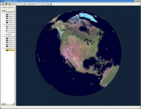
| هو اول برنامج يسمح لك بمشاهدت الكرة الارضية من الفضاء و ستكشاف العالم يمكنك الدهاب الى اي مكان بكل سهولة و بجودة عالية , في برنامج خصيات يمكنك مشاهدات الشوارع ستشاهد المنازل من جميع زواياها و شوارع ,من مميزات البرنامج مجاني و سريع و حجمه صغير و فيه جودة عالية و فيه الكثير من المميزات الاخرة مثل الرحلة الجوية و هيا عبارة عن جولة حول العالم و انت جالس في حسوبك,تحميل . الرخصة : مجانى License : Trial With the help of Earth3D you can view the globe in 3D mode, as well as zoom in to get a better perspective on a location. It doesn't include complicated options and lets you import other links with satellite images.
The app is portable, so you can run the executable file on any workstation from any source, whether it's the local hard drive, USB flash disk or other removable drive. What's more, no traces are left on the disk after removing the utility, and no new entries are added to the Windows registry.
The interface is made from a regular window with two tabs dedicated to source maps and the active one. You can double-click any source in the list to view Earth (e.g. with ice, with ice and clouds, at night), as well as add a new source from a market place or by inserting a link.
You can take screenshots, analyze texture in a separate panel, get GPS coordinates on a selected location, as well as check marker details in the status bar.
It is possible to adjust the quality and centerweight of the map, change the Earth view (normal, grid, or border), use proxies, multi-texturing, texture compression, and local caching (improves speed while reducing downloads), as well as modify the size and directory of the local cache.
The tool has a fair response time and uses a high amount of system resources. However, it takes a long time to clarify enhanced images and doesn't do a very good job in the end. Clearly, Earth3D cannot be compared to other, more powerful geographical information applications (like Google Earth), but we must also take into account that it has not been updated for a very long time.
 رابط مباشر للتحميل Direct Link To Earth3D v1.0.5 |
|